Cube-a is Stonex’s solution for professional surveying and GIS which has been designed and developed for the Android platform.
Thanks to the flexibility of the Android environment, StoneX has been able to create a simple and intuitive user interface that makes surveyors ready for any work, saving time and increasing productivity.
Full support for touch gestures and the possibility to install it on Smartphones and Tablets are the keys to the success of Cube-a.
It also includes support for many languages and adjusts its interface to the current system language setting.
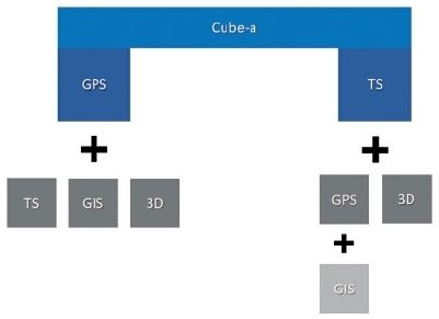
Cube-a is a modular application that can be customized as needed: GNSS, Robotic and Classic Total Stations, GIS, and 3D Modelling modules can be enabled to fulfill any customer need.
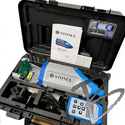
Please Note; Data Controllers Sold Separately
Features:
Stonex field solutions for GNSS RTK, GIS, and Total Station surveys will make operators’ work quick and easy, ensuring high productivity in all jobs requiring precision and efficiency.
Main Modules
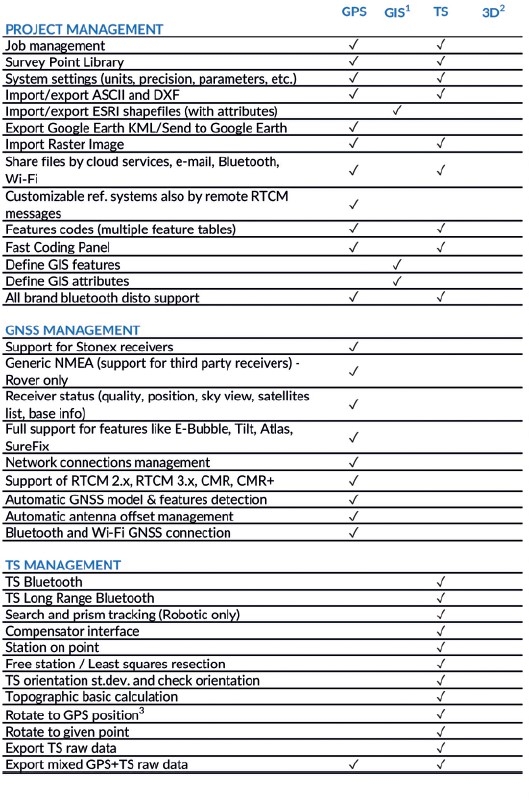
GNSS
Cube-a is compatible with all Stonex GNSS Receivers.
Supports Rover, Rover Stop&Go, Base, and Static modes.
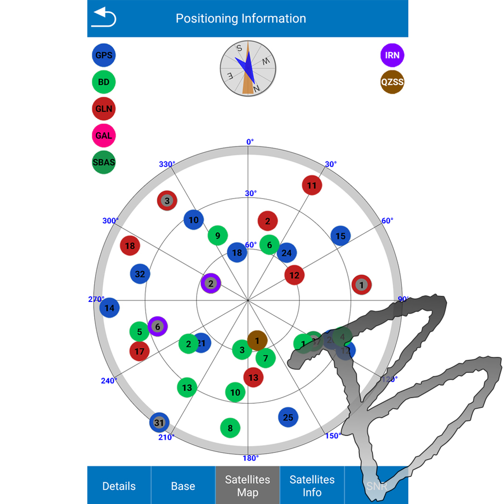
Various screens provide useful information on the status of the GNSS receiver including the position and the signal quality of the Atlas satellite.
Total Station
Cube-a has been designed to fully support mixed surveys.
A Cube-a survey supports GPS points and classical polar stations and measures at the same time.
Polar stations can be set to occupy previously collected GPS points or on unknown positions calculated using the Free Stationing program.
Likewise, the GPS reference system can be adjusted to match an existing polar survey in local coordinates.
Cube-a supports all Stonex Total Stations via Bluetooth.
ADD-ON MODULES
GIS
GIS functionalities are well integrated in the workflow of standard GPS surveying.
Thanks to the Cube-a’s ability to collect, not only single points but also to automatically draw vectors passing through the collected points, GIS surveying becomes fast and easy.
The request to fill in the GIS data is automatic and automatically follows the point or vector acquisition.
Data forms can be freely defined using the integrated Feature Set designer or automatically created by Cube-a starting from a sample DBF file.
Import and export of standard shapefiles ensures the compatibility and interoperability of Cube-a with virtually any other GIS software.
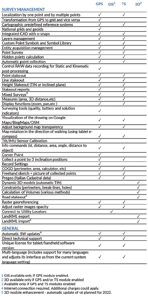
3D & ROADS
The 3D module adds a complete set of commands for performing real-time surface modeling.
Base points and constraints are selected by layer.
Optional constraints include a perimeter, break-lines and holes (closed non-triangulated areas).
The surface display mode is selectable from wireframe, filled triangles with edges, shaded triangles with edges or external perimeter with triangulated points.
Volume calculations can be easily defined between a model and a horizontal or inclined reference plane.
Results, as well as surface data, can be exported to various file formats.
Included in this module is the Roads function, which allows the stakeout of the centerlines/base road alignments, and cross sections.
The staking modes available are: by continuous interpolation along the alignment and by station points, elevation can be derived from the elevation profile, the nearest cross section, or by interpolation using previous and next cross sections.
The graph proposes two types of views: centerline/alignment and cross section.
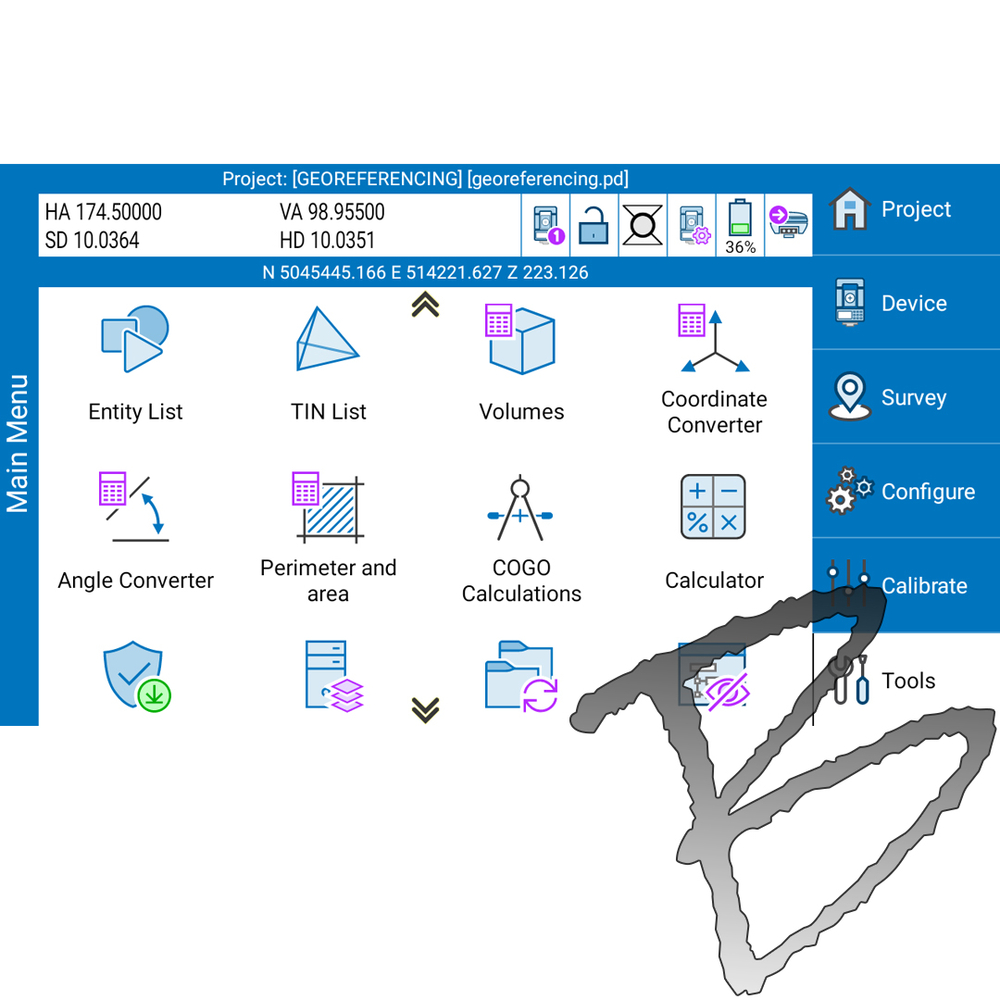
MAIN FUNCTIONALITIES
SKY PLOT
Various screens provide useful information on the status of GPS, StoneX also developed the possibility in the Sky Plot to read the presence of Atlas.
The innovation to show Atlas correction is in order to help and facilitate the work of surveyors so that, when this correction is needed, they can know if the satellite is seen and in what position.
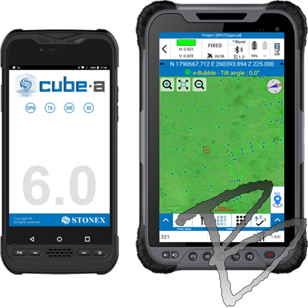
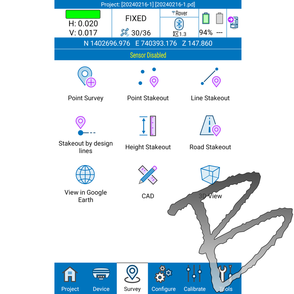
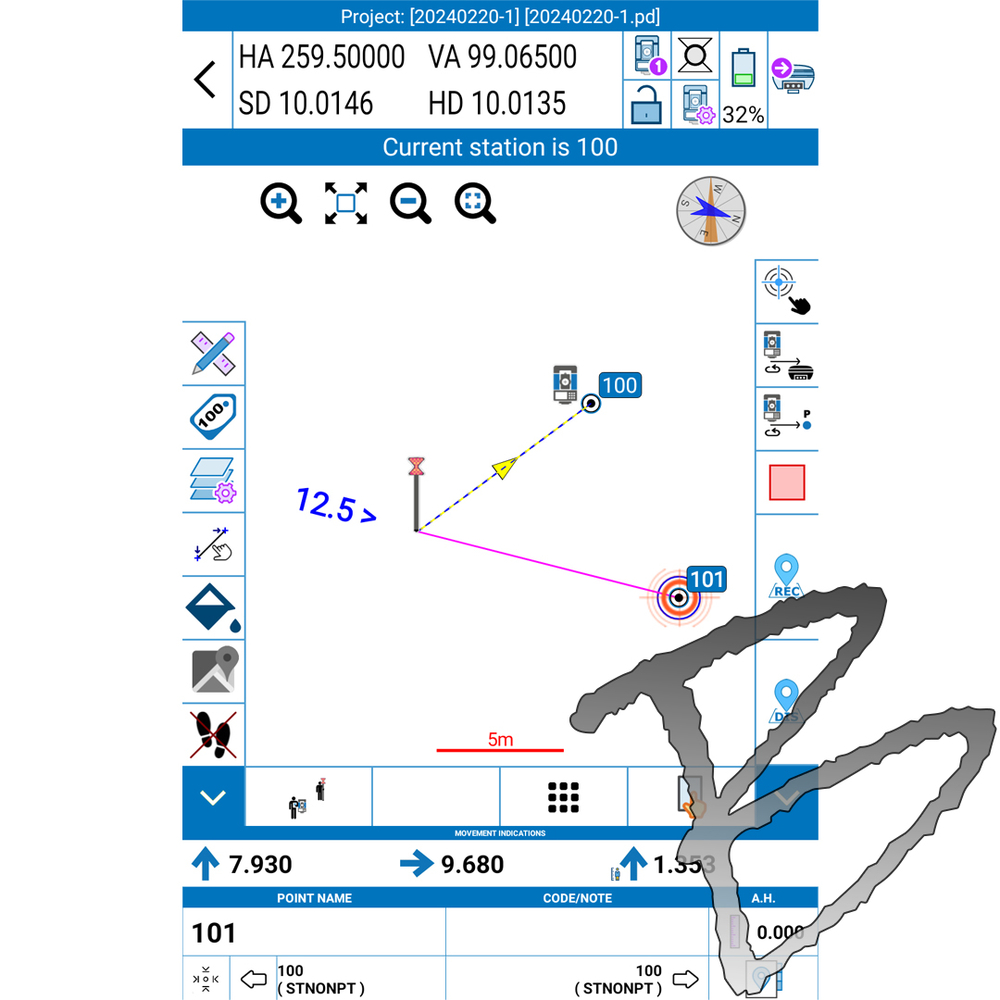
SURVEY
A simple and intuitive survey interface with numerous indicators immediately helps the surveyor to understand what kind of work and in what conditions is taking place.
Indicators show various information like solution status, position precision, battery levels, RTK correction delays, and more.
Intuitive screens allow for an easy change of settings, a view of the collected points, adding new CAD elements and drawings or proceed surveying.
PHOTO & SKETCH
To improve and complete the survey and stakeout functions, you can also use Photo & Sketch.
This function can be used while surveying or even on the already acquired points: take photos and add notes, add and position some indicating arrows or simple hand-drawn sketches.
STAKEOUT
A compact interface groups all the stakeout launching commands on one screen for easier work in the field.
Stakeout screens are enriched with both graphical and analytical indicators which guide the surveyor in order to reach the target point.
Thanks to this interface, you can read all the information necessary to complete the stakeout work, to select points or to add them and quickly change all settings.
Even in the case of small monitors, the information and commands are always smartly arranged and readable, the buttons are clickable without difficulty and some of them can be reduced to leave more space for the map.
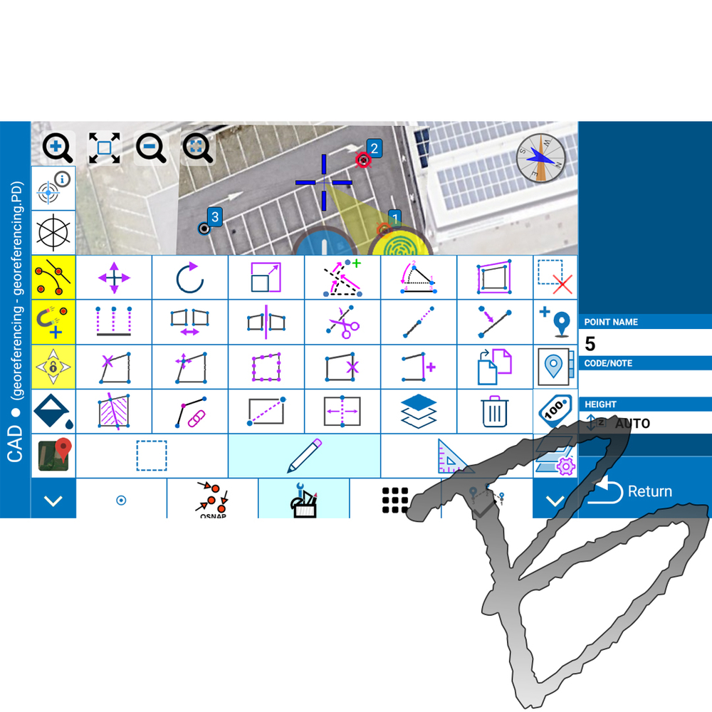
INTEGRATED CAD
Cube-a includes a smart and easy-to-use CAD feature.
The CAD has been designed to work with touch displays and it allows to easily draw points and other CAD entities by means of a smart pointer which can be moved using one finger and which always transmits to the user strong confidence of the result achieved.
The help of object-snaps like point, mid-point, end-point, intersection, and others makes it possible to integrate the survey with new elements directly in the field.